1/4


Buoy Map
1K+Downloads
19MBSize
2.2(12-12-2024)Latest version
DetailsReviewsVersionsInfo
1/4
Description of Buoy Map
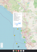
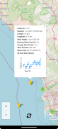
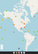
A world map with live buoy data provided by the United States National Oceanographic and Atmospheric Administration (NOAA). Updated every 30 minutes with the latest data, including last 48-hour wave height graphs.
Buoy data includes (each buoy has a different set of instruments so not all sensors apply to every buoy):
* Wind Direction
* Wind Speed
* Wind Gust Speed
* Wave Height
* Wave Height 48 Hour History (Graph)
* Dominant Wave Period
* Average Wave Period
* Wave Direction
* Air Pressure
* Air Pressure Trend
* Air Temperature
* Water Temperature
I plan to add new features frequently and I hope that you find this app helpful. Suggestions and constructive criticism is welcome.
Enjoy!
Buoy Map - Version 2.2
(12-12-2024)What's newThis release allows full screen on newer devices with "punchhole" cameras in the display and bumps to the latest target SDK 35. It also includes all new features from the previous release:* 48-Hour wave height history graph to buoys with wave height data.* If location permission is granted the app will now load the map near your devices last known location. If no location permission is granted the map will show your last viewed location.* Small misc improvements
Buoy Map - APK Information
APK Version: 2.2Package: com.ridelegend.ridelegendName: Buoy MapSize: 19 MBDownloads: 0Version : 2.2Release Date: 2024-12-12 08:35:48Min Screen: SMALLSupported CPU:
Package ID: com.ridelegend.ridelegendSHA1 Signature: C3:EF:BC:8F:DD:29:5E:A2:9A:3C:31:47:A1:94:94:5F:0D:B7:96:B6Developer (CN): Joel LisenbyOrganization (O): Local (L): San DiegoCountry (C): USState/City (ST): CaliforniaPackage ID: com.ridelegend.ridelegendSHA1 Signature: C3:EF:BC:8F:DD:29:5E:A2:9A:3C:31:47:A1:94:94:5F:0D:B7:96:B6Developer (CN): Joel LisenbyOrganization (O): Local (L): San DiegoCountry (C): USState/City (ST): California
Latest Version of Buoy Map
2.2
12/12/20240 downloads19 MB Size
Other versions
2.1
4/9/20240 downloads17.5 MB Size
2.0
15/11/20220 downloads2.5 MB Size
1.7
9/7/20200 downloads1.5 MB Size


Apps in the same category


English


